Bobcat Fire Blackens More than 20,000 Acres
Foothill communities issued evacuation warning
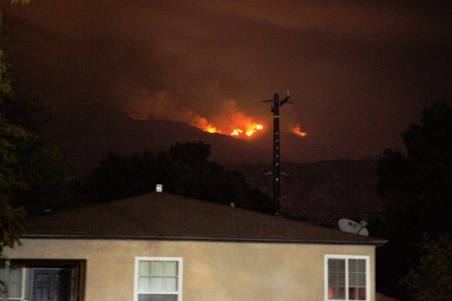
The bobcat fire rages behind a home in the hills above Monrovia, California on Sept. 9, 2020. Ashes can be see floating down and coating cars in a fine layer of grey dust. Smoke fills the air and can be seen in a dull gray haze beneath street lights. Photo credit: Abraham Navarro/SAC.Media
On Sunday, Sept. 6, what became known as the Bobcat fire began to burn in the Angeles National Forest near Azusa. As of Thursday, Sept. 10, it is zero percent contained and has burned approximately 23,890 acres.
According to InciWeb, an interagency information system that keeps track of natural incidents, the Bobcat fire is being fueled by chaparral, brush, and tall grasses that are extremely dry. It also said that the Santa Ana winds are pushing the fire south towards the foothill communities and will push it north and east of Highway 39 by the afternoon.
Areas immediately surrounding the Cogswell Dam are under mandatory evacuation and the cities Altadena, Pasadena, Arcadia, Monrovia, Sierra Madre, Duarte and Bradbury have been issued an evacuation warning.
Ash has been raining across surrounding cities, smoke clouds and a red sun have been hovering above for a few days. Abraham Navarro, 21, journalism major, describes what the fire and its effects look like from his home in West Covina:
“The light coming in through my windows has a slight yellow tint and I can see the smoke coming off the mountains. The sun is an almost sickly yellow and there are ashes, like salt and pepper, coating everything in sight. The air smells like old barbecue after the charcoal has cooled and dried and my mom’s birdbath has a thin layer of ash mud settling at the bottom.”
Bridgette Lugo, 31, Mt. SAC alumni, lives in Covina and works in Bradbury and described the scene of running errands with a wildfire burning in the neighboring city.
“I woke up to see my car covered in ash and had to use my windshield wipers to get it off,” Lugo said. “I went to Target and it was raining ash from Covina to San Dimas to Azusa. From the parking lot to the entrance, you had to blink a lot and close your eyes now and then because it would enter your eyes.”
Navarro has been experiencing worsening health conditions due to the ash falling heavily in the area.
“I have really bad allergies and recently I have been suffering from a skin condition so when I touch the ashes, my skin flares up. When I get ashes in my eyes, it starts getting super itchy and I scratch my eyes until they get swollen and get hives around them,” he said.
There are currently 43 fires raging across California with over 7,000 wildfires occurring in the state just this year. About 3.1 million acres have burned in total in 2020 and with the growth of new fires, this number continues to rise.
“Having to see that the mountain range where I have spent part of my childhood and where I have done so much with my family is on fire, it’s upsetting,” Navarro said.
With many places in California being forced to close due to the Stay At Home orders, for many people, going hiking or fishing was one of the only things to do to stay sane. Now even going outside is unsafe.
“It’s so upsetting to me because it is the one place of refuge you can go to through this whole pandemic to not feel that you are surrounded by people,” Lugo said.
Lugo works in a senior community in Bradbury and prepared an evacuation plan with the family of one elderly man that is living there. “It’s a whole gated senior community that they would all have to file out and that’s kind of scary.”
It is still unclear what started the Bobcat fire.
Monrovia is posting continuous updates on their website describing exactly what fire departments are doing to ensure the community stays safe. According to the website, “Two air tankers were able to make several drops of fire retardant on the southwest portion of the fire, which is right above Monrovia, to reinforce and strengthen previously applied fire lines.”
According to InciWeb, the estimated containment date is Oct. 15, 2020.
More information regarding the fires can be found at the Cal Fire website. Fire locations and evacuation zones can be tracked on the Los Angeles Times Wildfire Map.
For up-to-date local fire coverage, follow @SAConScene on Twitter.